
Ancient Rivers of Ice Flow for Centuries
Table of Contents
Glaciers have impacted much of the world’s landscapes at one time or another. Learn how they form, how they thrive, and how they die.
Glaciers flow down through mountains on the path of least resistance. These rivers of ice are built of serene silence, howling wind, and stunning beauty. Glaciers have carved mountains and plains all around the world and in the United States from the Northeast to Alaska where approximately 13 percent of the world’s glaciers still exist according to the American Geological Institute.
There are several categories of glaciers including Alpine (mountain and cirque) glaciers, Valley glaciers, Piedmont glaciers, and Icefields. This article predominantly concentrates on Alpine and Valley glaciers such as are found in much of Southeast Alaska and the Northern Rockies.
Different Than an Ice Cube
Glacier ice is not simply poured and frozen. It is compacted over many years. In areas where snow falls and does not melt or evaporate during the year it carries over to the next year. Before long there could be several hundred years’ worths of ice crammed into a mountainous area creating an ice field where some of the compacted snow-turned-ice begins to move downhill. The grains of snow actually endure a process called firnification when they are changed into glacier ice. During this process, the air spaces between the grains become airtight just as a handful of granola can compress when vacuum sealed in plastic.
The creeping masses of glacier ice flow with gravity and compression farther away from the ice field where the snow first fell, eventually creating a river of ice that carves its way through mountains and valleys. The glaciers push rocks out of their way and essentially bulldoze the landscape. Some glaciers are only a few miles long, whereas others such as the Lambert-Fischer glacier in Antarctica reach several hundred miles in length and span a width of more than 25 miles.
A Landscape in Motion
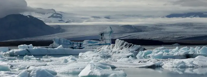
Glaciers sculpt the land they move through, as they flow with the aid of gravity and compression – pushing and carrying rock debris as they flow forward. Plowing through bedrock, the ice has a force like no other. Glaciers are what create deep fjords, flat outwash plains, deep lakes, and freezing rivers. Many mountains are scraped over and have rounded summits from receding glaciers during the last little ice age. The Appalachians are a prime example of rounded mountains from when ice scraped over them thousands of years ago. Sharp pointed peaks are a giveaway to where the ice level was; if a peak is still jagged then a portion of it always remained above the ice line.
Glacial meltwater, often green in color is dense with silt, or glacial flour which is the pulverized rock from the bulldozing action of the ice. In coastal areas such as Southeast Alaska glacial rivers flow right out to the ocean, mixing fresh cold water with the salty seas. Some glaciers, called intertidal glaciers, end right in the ocean. These glaciers have a greater chance of calving or breaking off in thunderous columns of blue ice because of the movement of water up against them.
Prehistoric Ice Sheets of Africa
What is now a continent covered with deserts and grasslands was once an ice sheet comparable to today’s Antarctica. Glacial deposits and striations mark the southern portion of the African continent and are evidence of a time when global sea levels were lower and cold temperatures persisted throughout much of the planet.
African Ice Sheets of the Late Paleozoic
African ice sheets existed in the southern portion of the continent 250-300 million years ago, or during the late Paleozoic era. The ice sheets extended from Antarctica into the African continent as global cooling dominated. The stratigraphic record of this era is incomplete in southern Africa – due to geological processes, mainly erosion – but in North America, there is evidence of repeated marine invasions. These sea-level fluctuations can be attributed to a period of cyclical ice build-up and decay of continental glaciers worldwide during the Pennsylvanian and Permian periods of the Paleozoic.
The cyclical fluctuation of sea levels worldwide led to the repeated burial and reburial of Pennsylvanian and Permian swamps, which today are the source of large deposits of hydrocarbons (fossil fuels) in North America. During this same period, the African continent was experiencing tectonic drifting, causing the land mass to slowly drift northwards away from the cold-weather influences of Antarctica. Currently, this continental drift is still active, making it unlikely that the African continent will ever experience a period of glaciation comparable to that of the late Paleozoic.
Evidence of Glaciation in Southern Africa
Geologists can always tell when there has been glaciation in an area because of the clues left behind. In Africa, these clues include:
- Striated bedrock
- Tillite formations
- Meltwater deposits
Striated bedrock forms as a result of the glacier scraping over the bedrock. As glaciers move over continents, they collect and deposit a variety of rocks along the way. Rocks at the bottom of the glacier scrape against the bedrock and leave striations in the direction of the scraping. This kind of glacial evidence is unique to glacial movement and provides information such as the rate and direction of movement to glaciologists.
Tillite forms as a result of the compaction and cementation of glacial till deposits. Till deposits form when glaciers drop the rocks that they are carrying as they retreat. Like a bulldozer, glaciers break and shove rock over land as it moves forward. When warmer temperatures ensue, the glaciers retreat, leaving behind unsorted piles of rock. These rocks are of different sizes and types – characteristic of a glacier that picks up everything and anything as it moves forward.
Meltwater deposits also referred to as meltwater stream sediments, form as a result of sand and gravel being transported by streams carrying water from a melting glacier. These sediments can also include a variety of rock types but are generally better sorted than till deposits so that the most prominent size of the rock is coarse sand and gravel.
Today, glaciers on the continent of Africa are restricted to the summit regions of a few African volcanoes, and even those are disappearing due to climate change.
Melting Glaciers
Many glaciers in this day and age are receding and contributing to a rise in sea levels worldwide. According to the Alaska Almanac, glaciers cover approximately 29,000 square miles – or 3 percent – of Alaska. Naturalist Linda Nicklin said that on average glaciers in Alaska are receding by 3 meters a year and if all of Alaska’s ice melted it would cause the oceans to rise half a meter. When a glacier is receding it means that even though there is still new ice being made and it is inching forward, it cannot produce enough ice to replace the amount lost through surface melt and calving at its end. Juneau, Alaska’s Mendenhall Glacier has been receding for the last 250 years.